Suburbs, Shires & Councils
Suburbs, Shires & Councils - City Guide
◉ Avalon 3212
Avalon
Avalon is an aeronautical establishment 55 km. south-west of Melbourne between the Princes Freeway and Corio Bay. The nearest town is Lara, 4 km. to the west.
An early owner of large land acreages in the Ava ..
◉ Barrabool 3221
Barrabool
Barrabool is an agricultural district 11 km. west of Geelong. It was also a shire until 1994.
The name is thought to be an Aboriginal word with several recorded meanings: oyster or a slope down to water or r ..◉ Barwon Heads 3227
Barwon Heads
Barwon Heads is a seaside township on the west side of the Barwon River where it enters Port Phillip Bay on the south side of the Bellarine Peninsula. It is 18 km. south-east of Geelong.
The name derives fro ..◉ Batesford 3221
Batesford
Batesford is a rural village on the Moorabool River near where it is crossed by the Midland Highway between Geelong and Ballarat. It is 10 km. north-west of Geelong and 67 km. south-west of Melbourne.
The na ..◉ Bell Park 3215
Bell Park
Bell Park is a residential suburb between Geelong North and Bell Post Hill. It was named after the Bell Park homestead built by an early settler John Bell. Part of the homestead is preserved in the buildings at ..◉ Bell Post Hill 3215
Bell Post Hill
Bell Post Hill is a residential suburb north-west of Geelong adjoining the Midland Highway or Ballarat Road.
Its name is thought to have arisen from a look-out post or warning bell on a post which was erecte ..◉ Bellarine 3221
Bellarine
Bellarine is a rural locality on the northern side of the Bellarine Peninsula, between Clifton Springs and Portarlington.
During the nineteenth century Bellarine was more extensive than today, probably inclu ..◉ Belmont 3216
Belmont
Belmont is a residential suburb 3 km. south-east of Geelong. It is bounded on the north and east side by the Barwon River and the riverside Belmont Common, on the south by Waurn Ponds Creek and on the west by H ..◉ Breakwater 3219
Breakwater
Breakwater, an industrial and residential area on the Barwon River, is 4 km. south-south-east of Geelong. Its name came from a rock ford constructed across the Barwon River by Geelongs first Police Magistrate, ..◉ Business | Venue Locator by Suburb
Australia
View venues and businesses by suburb
Step 1 - Select a suburb starting letter
Step 2 - View all suburbs with the starting letter
Step 3 - Select a suburb
Step 4 - View all venues and businesses ..
◉ Ceres 3221
Ceres
Ceres is a small township with an extensive district. The township is 8 km. west-south-west of Geelong; and the districts perimeter includes Ceres Lookout, 3 km. east of the township, the Barrabool Hills to the ..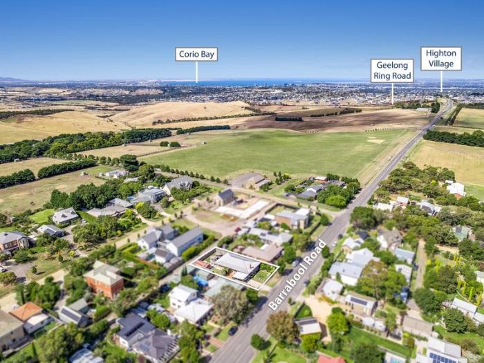
◉ Corio 3214
Corio
Corio is a residential and industrial suburb in the Geelong region, 9 km. north of Geelong and 56 km. south-west of Melbourne. It adjoins Corio Bay, which is on the western side of Port Phillip Bay. It is thoug ..◉ Geelong 3220
Geelong
Geelong, Victorias largest provincial urban region, is 65 km. from central Melbourne across the Port Phillip and Corio Bays. It is on the Princes Highway between Melbourne and Victorias Western District.
Hum ..
◉ Geelong East 3219
Geelong East
Geelong East is a residential area with large public open spaces, adjoining the Geelong central city area. Its northern edge is the Corio Bay foreshore, and it extends southwards to Breakwater. Boundary Road se ..◉ Geelong North 3215
Geelong North
Geelong North is a residential and industrial suburb on the west side of Corio Bay. It is separated from Geelong by Geelong West. Its northern boundary, Cowies Creek, separates it from Norlane, where the Ford M ..◉ Geelong South 3220
Geelong South
Geelong South is a residential area between the Geelong central city area and the Barwon River.
A prominent feature of Geelong South is Kardinia Park, home of the Geelong Football club since 1940. Originally ..◉ Geelong West 3218
Geelong West
Geelong West is a residential suburb immediately adjoining Geelong on Corio Bay, which is on the western side of Port Phillip Bay. Between 29 May, 1875, and 18 May, 1993, Geelong West was also a municipality, w ..
◉ Leopold 3224
Leopold
Leopold, a residential and rural district on the Bellarine Peninsula, is 10 km. east-south-east of Geelong. Originally name Kensington, it was renamed Leopold in 1892 after Queen Victorias son, the Duke of Alba ..◉ Little River 3211
Little River
Little River is a rural township 44 km. west-south-west of Melbourne, on the train route to Geelong.
The Little River (shorter than the Werribee River to its east and the Moorabool River to its west), has he ..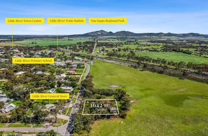
◉ Moriac 3240
Moriac
Moriac is a rural township 20 km. south-west of Geelong, on the railway line to Colac. Mt. Moriac, the older of the two places, is on the Princes Highway and is about 2 km. north of Moriac. The actual mountain, ..◉ Newcomb 3219
Newcomb
Newcomb, a residential suburb adjoining Geelong East, is 3 km. south-east of Geelong. It is named after Caroline Newcomb, companion of Anne Drysdale who was a pioneer pastoralist in the Drysdale district.
Or ..◉ Norlane 3214
Norlane
Norlane is a residential suburb immediately north of the Ford motor plant in Geelong. It was named after Norman Lane, a local serviceman from the district who was captured at Singapore and died working on the B ..◉ Portarlington 3223
Portarlington
Portarlington, a coastal township on the north-east side of the Bellarine Peninsula, is 26 km. east of Geelong and 43 km. across Port Phillip Bay from the centre of Melbourne.
The origin of the name is obscu ..◉ Queenscliff 3225
Queenscliff
Queenscliff is a township at the entrance to Port Phillip Bay, named by Lt. Governor C. J. La Trobe after Queen Victoria in 1853. Before then the settlement had been called Whale Head and Shortlands Bluff.
Q ..
◉ Werribee 3030
Werribee
Werribee, about 27 km south-west of Melbourne, is midway on the Princes Highway to Geelong. It is situated on the Werribee River, which has its headwaters north of Ballan.
Early pastoral leaseholds included ..◉ Werribee South 3030
Werribee South
Werribee South is a rural area on alluvial land at the southern end of the Werribee River where it enters Port Phillip Bay. It is situated on the east side of the river and extends further eastwards to Point Co ..